
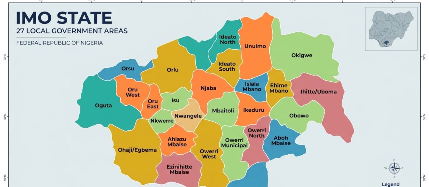
Overview
Imo State lies in Nigeria's South East and was created on 3 February 1976 from the former East Central State, with Owerri as its capital. Its territory was later reduced when Abia State was carved out in 1991. Imo is one of the most densely populated states in Nigeria and is almost entirely Igbo-speaking. Owerri has grown into a significant administrative, educational and commercial centre, while the state as a whole retains a strong tradition of trade, small-scale enterprise and, for many communities, emigration to other parts of Nigeria and abroad in pursuit of commerce and education. Known by the nickname "Eastern Heartland", Imo combines a largely Christian population with enduring Igbo cultural institutions such as masquerade traditions and title societies.
History
Before colonial rule, the area of present-day Imo State was inhabited by numerous autonomous Igbo communities organised around village-group governance rather than centralised kingship, with notable trading and farming settlements across what became Owerri, Orlu and Okigwe divisions. British colonial administration incorporated the area into Owerri Province within the Eastern Region from the early 20th century. Following Nigerian independence and the creation of East Central State after the civil war, Imo State was created on 3 February 1976, taking its name from the Imo River. At creation it included territory later split off in 1991 to form Abia State, which reduced Imo to its present extent. Owerri, historically a colonial administrative centre, was retained as the state capital.
Geography
Imo State occupies gently undulating lowland terrain typical of the South East rainforest belt, with the Imo River forming part of its eastern boundary and numerous smaller streams draining the state. Vegetation is largely derived savanna and secondary forest, most original rainforest having been cleared over generations of dense settlement and farming. The state has a tropical climate with a long rainy season from April to October and high annual rainfall. Imo, like neighbouring Abia and Anambra, is affected by gully erosion in several local government areas, a consequence of heavy rainfall acting on loose sandy soils, which has damaged roads, farmland and buildings in some communities and remains a significant environmental management challenge for the state government.
Economy
Imo's economy is built on trade, small-scale manufacturing and agriculture, with Owerri serving as a hub for retail, real estate and public administration. Agriculture remains widespread outside urban centres, with cassava, yam, oil palm and vegetables among the principal crops grown by smallholder farmers. The state has modest oil and gas resources in its southern reaches near the Niger Delta fringe, supporting some petroleum-related activity. Imo people are widely noted for entrepreneurship and are prominent in trade and commerce across Nigeria and in the diaspora, with remittances forming a notable, if unofficial, contributor to household incomes. Government efforts have focused on infrastructure development in Owerri and on addressing erosion damage that affects agricultural land in several areas.
Next from Imo: read about the Igbo who live here, or try the food, starting with Ofe Owerri.
Landmarks
Nekede Zoological Garden, Owerri
A zoo and conservation centre near Owerri housing a range of native and other animal species.
Oguta Lake
A large natural freshwater lake associated with local folklore and recreation.
Mbari cultural sites
Traditional Igbo art and shrine houses historically associated with Owerri-area communities.
Peoples of Imo
- IgboDominant
Igbo
Languages spoken
Food from Imo
- Ofe Owerrisoup
A dense, protein-heavy soup thickened with cocoyam and ofor, combining ugu and okazi leaves with a large amount of assorted meat, stockfish and dried fish. It is the most expensive of the Igbo soups to cook properly.
Culture and custom
- Culture
Age grade systems
Igbo age grades group people born within a set span of years into lasting associations that build roads, settle disputes and still operate alongside town unions today.
- Culture
Funerals and Second Burials
Among the Igbo, burying the body is only the first step; a later, often costly second burial confirms the deceased's standing among the ancestors and the family's standing among the living.
- Culture
The Igbo kola nut ritual
The breaking of ọ̀jị̀, the kola nut, opens Igbo gatherings and hospitality, following strict seniority, a spoken prayer, and a reading of the lobes it yields.
More from South East
Spotted something wrong? Tell us.